A couple of weeks ago while Googling for images of 19th Century Afghan bridges (well, everyone has their own idea of fun!) I stumbled across a somewhat amazing discovery: an October 2001 article from Boston Univesity's "Bridge" newspaper, about a Waziri tribal banner that was used in at least one battle with British forces in 1894, recovered by the British and donated to the school's Library years later by the son of an Anglo-Indian civil servant who was part of a mission to delineate the border with Afghanistan when the battle took place.
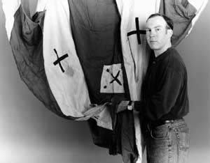
Here's a photo from the article, showing an archivist standing the banner rather inarttfully gathered inhis hands:
...and here's a link to the article:
link
For most of my life I've been interested in the Anglo-Afghan wars and the history of the North-West Frontier. One of the thigns I've learned is that detailed description, photos, and illustrations of the flags used by the native forces in these campaigns are few and far between.
If I still lived in NYC I would get in touch with the BU Library myself and -- so long as the flag is still there, which there's no reaon to doubt it is -- do my best to arrange a visit and get some good color photos of the entire flag FULLY UNFURLED... but I live in Los Angeles, so unfortunately that simply not possible.
The small crosses visible in the photo don't look like any Pashtun symbols I know, but I'm no expert and I know I'd love to see the WHOLE FLAG, which happens to be described as being TRIANGULAR -- the shape Pashtun tribal flags are almost always described as being.
I have sent an email to the school in hopes of hearing back but haven't heard anything yet. This may be due to it being the midst of the Holiday Season... or not. If and when I do hear back I will certainly share any new info, but... in the meantime, my question for everyone out there in the Colonial Wargaming blogosphere is....
If the flag is still there, is one of us willing and able to visit Boston University, take some pics and post them somewhere online for the rest of us to see?
There must be ONE WARGAMER interested in the history of the North-West Frontier living within reach of Boston University... musn't there???
On a distantly-related note, I'm happy to report my son was just accepted to his "Early Decision" college choice -- Cornell University in upstate New York, which though it's a great school, is obviously not located in Boston. So my questions mreains: is there someone out there who can take it upon themselves to further investigate this Tribal banner for the rest of us...???
Being a mostly visual diary of the creation of high quality, historically accurate 25mm/28mm scale terrain for a refight of the battle waged by the British and Afghans on July 27th, 1880, in time for its recent 130th anniversary on Tuesday, July 27th, 2010.
Above is a pic of Lt. Colonel James Galbraith, Regimental Colour in hand, alongside Bobbie the regimental dog and some of the other "Last Eleven" survivors of the 66th (Berkshire) Regiment, making their last stand in one of the walled gardens just South of Khig village, a few miles West of the Afghan town of Maiwand.
Wednesday, December 24, 2014
Thursday, December 11, 2014
Charasiab preview
Well I'm not done with my Charasiab lay-out just yet, but... I'm happy to report I am a bit closer to it!
Finished up gluing down and painting the ground-cover on the Kabul River terrain board. Before moving on to paint the river itself to match the pair of previously compelted Logar River boards, I couldn't keep myself from laying out the whole dang thing just to see how it would look.
It's still far from finished though! Here's a list of what remains to be done...
(1) ROADS: Most of the roads are NOT the 3" wide acrylic caulk roads I started making months ago and will continue making for this lay-out after I finish both rivers, instead they're 4" wide roads I made years ago from thin sheets of craft foam.
(2) CROP FIELDS : I need to make a lot more of these to cover the area on both banks of the Kabul River and between the Logar River and the Karez (man-made irrigation canal).
(3) EASTERN BLUFFS: I plan to build a tall, steep mountain (about 6" wide, 30" long, and 14" high) to place at the North-East the edge of the table beside the East bank of the Logar River, where a large mountain stands in real life. Months ago I started prepping a big piece of cork bark for this purpose. If it works it should be a bit like a more textured 3-D version of the illustrious General Tremorden Rederring's cardboard mountain profiles.*
(*If you've never seen these, I encourage you to check them out by visiting the page devoted to them on the good General's site, now reachable only through the "WayBack" machine, by clicking here: THE MAJOR GENERAL'S MOUNTAIN PAGE. His entire site is a treasure-trove of wonders for miniature wargamers in general and Colonial wargamers in particular. The main page can be reached here: THE MAJOR GENERAL'S WEBSITE)
(4) THE VILLAGE & HAMLETS: In the pic below the Northern edge of Charasiab village, and the hamlet of Khairabad are stood in for by temporary place-holders from the set of buildings made for me a couple of years ago by Chris Riordan, AKA: Chris The Model Maker, for the 150th Anniversary Battle of Camerone game I put on. The hamlet of Hindiki (sometimes called "Hinduki" or "Indiki") is stood in for by a couple of Pathan village buildings from Britannia/Stronghold models, which last I checked were no-longer commercially available. If you're interested you can read a blog post I wrote about painting them back in August 2011 by clicking here:
BRITANNIA/STRONGHOLD PATHAN VILLAGE
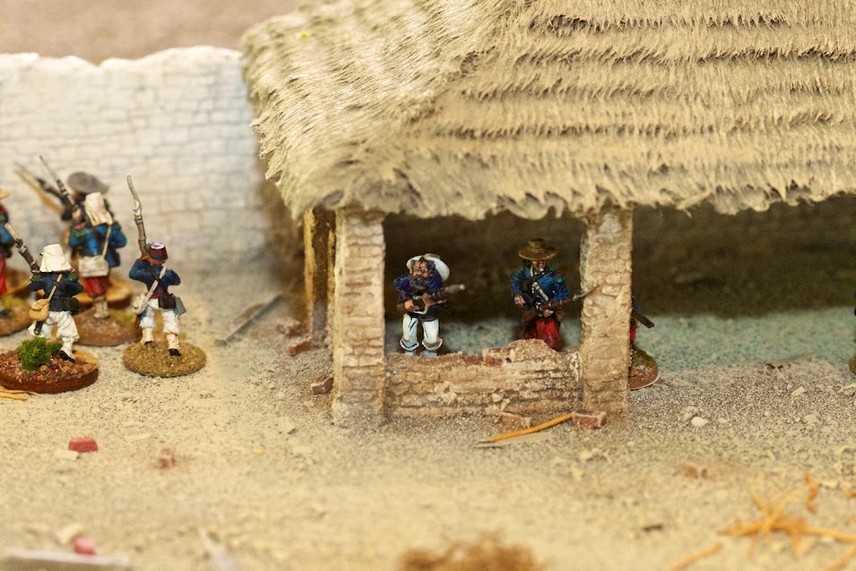
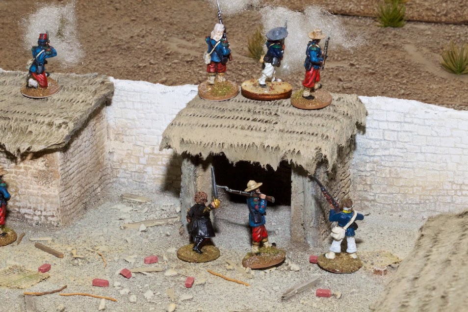
Here's some pics of those Camerone buildings built by Chris The Model maker in action at the 150th Anniversary game we played back on April 30th 2013:
If you'd like to see more, you can click here and pop over to my "Camerone Day" blog to see many more, you can click here:
Some nice pics of the Camerone Anniversary game
Many more Camerone game pics
Since all these buildings -- the Mexican ones and the Pathan ones -- were purposefully painted to go with my terrain boards, their color schemes fit the table very well, which is why I used them instead of other Pathan village buildings I have which are nice but whose color scheme would have stood out much more.
A while back I commissioned Chris to build Charasiab, Khairabad, and Hindiki for me as well. The name Charasiab is generally translated to mean "FOUR WATERWHEELS" in Farsi, and thanks to its position between the Kabul and Logar Rivers, the village had and to this day continues to have an abundance of water-power. A while back I posted a pic labelled "Charasiab Canal" from Google Earth showing a torrential water-plume in the modern village. The waterwheels that gave the Charasiab its name are the central element of the scenic build. Knowing how talented Chris is and having seen many examples of Afghan/North-West Frontier buildings he's created in the past, I'm very excited to see how these turn out and then be able to place them on my tabletop. But they're not done yet, so for now a few of his Mexican village buildings are standing in, since their color scheme is a perfect match for the table.
(5) Talab Khairabad (the Khairabad Marsh or Swamp) -- I'm using a few pieces of corn-field terrain to stand-in for the marsh on the bank of the Logar River. I've been planning since early this past Summer to custom build an "set-down" swamp, using some of the same materials I'll be using to finish the rivers, but then about a week ago the thought struck me that after going to such lengths to build the two river boards for this battle... why not build a swamp board too? Of course the simple reply is: BECAUSE IT WILL TAKE EVEN MORE TIME AND EFFORT YOU SILLY MAN! But, having expended so much of that already, I may yet succumb to the siren call and construct a 2'x4' board including a built-in swamp area AT AND BELOW SURFACE LEVEL rather than sitting atop it as was my original -- quicker but less artful -- plan. I'm still not sure on this one, but will keep you posted as the swamp progresses, one way... or another!
I'll be back with one of my elaborate posts detailing how I finished gluing and painting the ground-cover for the Kabul River terrain-board, but for now I'm only posting this pic of the 12'x6' lay-out, which -- using the ground scale of 1" = 50 yds. -- covers about 4 miles wide by 2 miles deep, accurately recreating the size of the field in Afghanistan's Logar Valley where the battle of Charasiab was fought on October 6th, 1879...
NOTE: please click on the photos to enlarge!
Here's the lay-out:
...and here it is again with the notable terrain features annotated:
Similarly kilted highlanders with Pouch-Belt equipment & Martinis -- and perhaps bedrolls as well -- have been promised by Empress for their Anglo-Zulu War range sculpted by the also very-talented Paul Hicks, as part of their stated objective of releasing every troop type that served in the Anglo-Zulu War of 1879 and the First Boer War of 1880-81 (the 92nd were dispatched straight from having fought in Afghanistan to join the campaign in the Transvaal, so they were dressed, armed and equipped the exact same way in both wars), but there's no sign of them arriving any time soon, so I will be buying a unit of Mike Owen's version for use as the 92nd.
Finished up gluing down and painting the ground-cover on the Kabul River terrain board. Before moving on to paint the river itself to match the pair of previously compelted Logar River boards, I couldn't keep myself from laying out the whole dang thing just to see how it would look.
It's still far from finished though! Here's a list of what remains to be done...
(1) ROADS: Most of the roads are NOT the 3" wide acrylic caulk roads I started making months ago and will continue making for this lay-out after I finish both rivers, instead they're 4" wide roads I made years ago from thin sheets of craft foam.
(2) CROP FIELDS : I need to make a lot more of these to cover the area on both banks of the Kabul River and between the Logar River and the Karez (man-made irrigation canal).
(3) EASTERN BLUFFS: I plan to build a tall, steep mountain (about 6" wide, 30" long, and 14" high) to place at the North-East the edge of the table beside the East bank of the Logar River, where a large mountain stands in real life. Months ago I started prepping a big piece of cork bark for this purpose. If it works it should be a bit like a more textured 3-D version of the illustrious General Tremorden Rederring's cardboard mountain profiles.*
(*If you've never seen these, I encourage you to check them out by visiting the page devoted to them on the good General's site, now reachable only through the "WayBack" machine, by clicking here: THE MAJOR GENERAL'S MOUNTAIN PAGE. His entire site is a treasure-trove of wonders for miniature wargamers in general and Colonial wargamers in particular. The main page can be reached here: THE MAJOR GENERAL'S WEBSITE)
(4) THE VILLAGE & HAMLETS: In the pic below the Northern edge of Charasiab village, and the hamlet of Khairabad are stood in for by temporary place-holders from the set of buildings made for me a couple of years ago by Chris Riordan, AKA: Chris The Model Maker, for the 150th Anniversary Battle of Camerone game I put on. The hamlet of Hindiki (sometimes called "Hinduki" or "Indiki") is stood in for by a couple of Pathan village buildings from Britannia/Stronghold models, which last I checked were no-longer commercially available. If you're interested you can read a blog post I wrote about painting them back in August 2011 by clicking here:
BRITANNIA/STRONGHOLD PATHAN VILLAGE
Here's some pics of those Camerone buildings built by Chris The Model maker in action at the 150th Anniversary game we played back on April 30th 2013:
If you'd like to see more, you can click here and pop over to my "Camerone Day" blog to see many more, you can click here:
Some nice pics of the Camerone Anniversary game
Many more Camerone game pics
Since all these buildings -- the Mexican ones and the Pathan ones -- were purposefully painted to go with my terrain boards, their color schemes fit the table very well, which is why I used them instead of other Pathan village buildings I have which are nice but whose color scheme would have stood out much more.
A while back I commissioned Chris to build Charasiab, Khairabad, and Hindiki for me as well. The name Charasiab is generally translated to mean "FOUR WATERWHEELS" in Farsi, and thanks to its position between the Kabul and Logar Rivers, the village had and to this day continues to have an abundance of water-power. A while back I posted a pic labelled "Charasiab Canal" from Google Earth showing a torrential water-plume in the modern village. The waterwheels that gave the Charasiab its name are the central element of the scenic build. Knowing how talented Chris is and having seen many examples of Afghan/North-West Frontier buildings he's created in the past, I'm very excited to see how these turn out and then be able to place them on my tabletop. But they're not done yet, so for now a few of his Mexican village buildings are standing in, since their color scheme is a perfect match for the table.
(5) Talab Khairabad (the Khairabad Marsh or Swamp) -- I'm using a few pieces of corn-field terrain to stand-in for the marsh on the bank of the Logar River. I've been planning since early this past Summer to custom build an "set-down" swamp, using some of the same materials I'll be using to finish the rivers, but then about a week ago the thought struck me that after going to such lengths to build the two river boards for this battle... why not build a swamp board too? Of course the simple reply is: BECAUSE IT WILL TAKE EVEN MORE TIME AND EFFORT YOU SILLY MAN! But, having expended so much of that already, I may yet succumb to the siren call and construct a 2'x4' board including a built-in swamp area AT AND BELOW SURFACE LEVEL rather than sitting atop it as was my original -- quicker but less artful -- plan. I'm still not sure on this one, but will keep you posted as the swamp progresses, one way... or another!
I'll be back with one of my elaborate posts detailing how I finished gluing and painting the ground-cover for the Kabul River terrain-board, but for now I'm only posting this pic of the 12'x6' lay-out, which -- using the ground scale of 1" = 50 yds. -- covers about 4 miles wide by 2 miles deep, accurately recreating the size of the field in Afghanistan's Logar Valley where the battle of Charasiab was fought on October 6th, 1879...
NOTE: please click on the photos to enlarge!
Here's the lay-out:
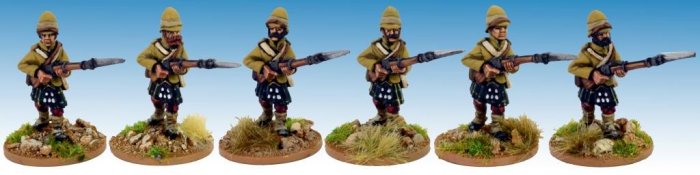
***One other nice development on the Charasiab front to report: ARTIZAN DESIGNS have released Highland infantry in kilts and foreign service helmet, carrying Martini-Henry rifles and wearing old "Pouch-Belt" equipment, making them perfectly appropriate for the 92nd "Gordon Highlanders" who fought at Charasiab, and played a key role in the British victory there:
This is just the latest entry in their new and expanding Second Afghan War range, sculpted by the very-talented Mike Owen, which includes a lot of nice figures. If you'd like to you can check them out here:
Tuesday, November 18, 2014
Form of Kabul River
Many of you will be familiar with the Kipling poem "Ford o' Kabul River". I've been a Kipling fan since I was a boy, so despite the fact that the tragic river-crossing which befell the 10th Hussars on March 31, 1879, cost the lives of 19 officers & men and later inspired Kipling's haunting verse, occured five months before the battle of Charasiab... I still couldn't resist the title tie-in for this blog post.
Here's a LINK to the poem in full:
FORD O' KABUL RIVER
...and here's a LINK to a very interesting page devoted to the tragic incident over at Garen Ewing's Second Anglo-Afghan War web-site:
THE INCIDENT THAT INSPIRED KIPLING'S POEM
Moving on to the matter at hand... for the last two months or so I've been working on the 6'x2' Kabul River board which -- hopefully in the not-too-distant future -- will lie on the far West edge of my 6'x12' lay-out for the Battle of Charasiab.
Considering how busy I've been with work and family, two months really isn't too bad. All that remains to complete it is gluing sand and pebbles onto the ground surface on either side of the river and then painting the board. Once that's done this board will have caught up with my previously built pair of 2'x2' Logar River boards, which will mean I'll FINALLY be able to mix and pour the resin and really finish these rivers!
Here's my usual overabundance of pics obsessively documenting the process of drawing, carving, framing, gluing, adding "rocky" wood-chips, and finally puttying the board...
(1) Consult Google Earth for map of Kabul River in the area of the Charasiab battlefield...
Here's a LINK to the poem in full:
FORD O' KABUL RIVER
...and here's a LINK to a very interesting page devoted to the tragic incident over at Garen Ewing's Second Anglo-Afghan War web-site:
THE INCIDENT THAT INSPIRED KIPLING'S POEM
Moving on to the matter at hand... for the last two months or so I've been working on the 6'x2' Kabul River board which -- hopefully in the not-too-distant future -- will lie on the far West edge of my 6'x12' lay-out for the Battle of Charasiab.
Considering how busy I've been with work and family, two months really isn't too bad. All that remains to complete it is gluing sand and pebbles onto the ground surface on either side of the river and then painting the board. Once that's done this board will have caught up with my previously built pair of 2'x2' Logar River boards, which will mean I'll FINALLY be able to mix and pour the resin and really finish these rivers!
Here's my usual overabundance of pics obsessively documenting the process of drawing, carving, framing, gluing, adding "rocky" wood-chips, and finally puttying the board...
(1) Consult Google Earth for map of Kabul River in the area of the Charasiab battlefield...
(2) Copy the path of the River onto the surface of the 6' board...
(Here's the 2'x6' sheet of double-tempered hardboard)
(3) Transfer river outline from one board onto the other...
(A NOTE OF EXPLANATION: I first drew the river onto the foam board BEFORE I had trimmed it down from 2' wide to 22-1/2". Since I didn't want to have to trim foam off two edges instead of only one, this meant re-drawing the river onto the other side of the board. I was very happy with the way the river looked, so instead of redrawing it from scratch, I traced it onto a sheet of white craft paper, then cut it out and used it as a template for redrawing the river itself. A lot of arguably needless effort but I was happy with the results.)
(A MORE POSITIVE NOTE OF EXPLANATION: the reason I had two boards instead of one is at some point months ago while carving a one-inch deep river channel out of a two-inch deep sheet of styrofoam insulation board, I realized it would be much easier to use two one-inch thick sheets of foam and simply cut the river out from between its banks and then glue them onto the second sheet.)
(4) Cut the river out from between its banks...
(NOTE: first cut goes right down the CENTER,
second two cuts -- one on each side -- along
the INNER EDGE of the river-bank slopes!)
(With the banks separated, cut the slope along
DIAGONAL connecting base of slope of with top of slope...)
(5) Glue river banks on top of second 6'x2' foam sheet...
(Explanation in advance: I had already cut a pair of 3/4" thick pine moldings to size to frame the two 2' long river edge pieces. Originally I thought I'd just use them and leave the rest of the styrofoam board edges unprotected, since that's how I'd built all 6 of the Maiwand boards. But... the more I thought about it the more I thought these river boards are a different animal and are taking so much time and effort I should probably frame the entire 6'x2' board with wood, same as I had framed the two 2'x2' boards with wood all around, so... I bought some more 3/4" molding...)
(6) Rip 3-1/2"x3/4" pine molding down to 2" height so it matches depth of styrofoam, cut lengths to frame board, counter-sink screws, glue and screw frame pieces to Masonite baseboard...
(Finally, one 3/4" thick framed river box...)
(7) Measure, mark, and TRIM foam boards to fit frame box...
(8) GLUE into place...
(9) Add "rocky" wood-chips (using a HOT GLUE GUN) to help blend the river into the nearby rocky hill rest of the overall terrain lay-out...
(10) With the "rocks" in place, break out the Elmer's WOOD FILLER to putty over the exposed river channel, bind together the wood-chips, blend them into the foam, and add some patches of texture to the ground cover on both sides of the river...
Only downside, if there is any, to the fully wood framed 6' board is that it is a bit heavier than it would've been with the wood frames only at the short ends where the river runs out, but overall I'm still happy I did it this way. I'm already halfway done with a "compromise" approach I'm using for the 6'x2' plain flat ground-cover board I need for Charasiab, which I'll blog about some time in the future after it's all done, meanwhile...
NEXT UP: Gluing the sand & pebble ground-cover onto this Kabul River board...
Subscribe to:
Posts (Atom)